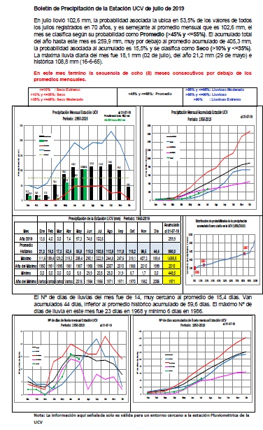
CENTRO NACIONAL DE HURACANES
Atlantic 2-Day Graphical Tropical Weather Outlook
|

| This product is updated at approximately 2 AM, 8 AM, 2 PM, and 8 PM EDT from June 1 to November 30, with special outlooks issued at any time as conditions warrant. The graphic displays all currently active tropical cyclones, and disturbances with tropical cyclone formation potential over the next 48 hours. Mousing over the symbol for each weather system displays details for that system; clicking on disturbance symbols or numbers toggles a zoomed view on or off. For additional NHC products on active tropical cyclones, click on the tropical cyclone symbols. |
| Tropical Weather Outlook Text |
ZCZC MIATWOAT ALL
TTAA00 KNHC DDHHMM

TROPICAL WEATHER OUTLOOK
NWS NATIONAL HURRICANE CENTER MIAMI FL
800 AM EDT THU SEP 29 2016

For the North Atlantic...Caribbean Sea and the Gulf of Mexico:

The National Hurricane Center is issuing advisories on Tropical
Storm Matthew, located over the eastern Caribbean Sea.

Tropical cyclone formation is not expected during the next 5 days.

&&
Public Advisories on Tropical Storm Matthew are issued under
WMO header WTNT34 KNHC and under AWIPS header MIATCPAT4.
Forecast/Advisories on Tropical Storm Matthew are issued under
WMO header WTNT24 KNHC and under AWIPS header MIATCMAT4.

$$
Forecaster Brown
NNNN